Log in
All resources
Create a design
5,084 Free Artworks of Pages With Maps
maps from the earth and its inhabitants, vol. iv
maps indicating exploration
maps from the earth and its inhabitants, vol. xiii
maps from the earth and its inhabitants, vol. ix
drawing
digital library of university of wroclaw
maps from the earth and its inhabitants, vol. vii
maps from the earth and its inhabitants, vol. xii
national library of poland
maps from the earth and its inhabitants, vol. xv
travel maps of the united kingdom
australia (1873) by booth
maps from the earth and its inhabitants, vol. iv
maps of lewis, scotland
civitates orbis terrarum. contrafactur und beschreibung von den vornembsten stetten der welt. liber tertius
maps of philippeville by braun & hogenberg
civitates orbis terrarum. contrafactur und beschreibung von den vornembsten stetten der welt. liber tertius
maps of arnhem by braun & hogenberg
maps by gouverneur k. warren
maps by edwin freyhold
maps from the earth and its inhabitants, vol. ix
exploration of arabia
german renaissance,northern renaissance
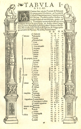
ptolemy's 1st asian map
french-language maps
david du vivier
maps from the earth and its inhabitants, vol. v
maps of sea ice
maps from the earth and its inhabitants, vol. vii
floods in china
ismailïa. a narrative of the expedition to central africa for the suppression of the slave trade (1874)
1874 maps of africa
maps from the earth and its inhabitants, vol. xiii
exploration of africa
john rocque's 1746 map of london
old and new london (book)
stedenboeken van de wereld by johannes janssonius 1657
maps of bruges by braun & hogenberg
stedenboeken van de wereld by johannes janssonius 1657
map of ghent by jan blaeu
wanderings, south and east (1882)
old maps of polynesia
maps from the earth and its inhabitants, vol. xii
1710s maps of africa
maps from the earth and its inhabitants, vol. iv
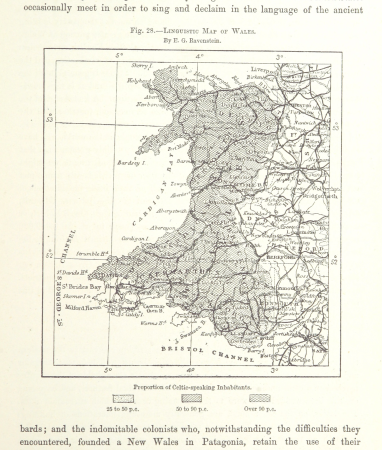
linguistic maps of wales
maps from the earth and its inhabitants, vol. xiii
maps of orange free state
maps from the earth and its inhabitants, vol. xiv
19th-century maps of borneo
maps from the earth and its inhabitants, vol. x
1910s maps of somalia
ghosts & ghoulish scenes
old maps of south africa
maps of transvaal
nouveau cours d'instruction primaire de géographie (1886)
1886 maps of africa
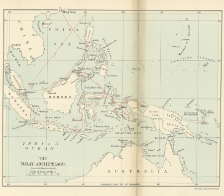
19th-century maps of the malay archipelago
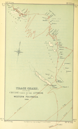
the cruise of the marchesa (1889)
old hemisphere world maps (partner files)
arnold's geographical handbook (1899)
collections of the british library
the child's geography (1879)
vrbivm praecipvarvm mvndi theatrvm qvintvm (1617)
maps of zell (mosel) by braun & hogenberg
a voyage to abyssinia, and travels into the interior of that country, executed under the orders of the british government in the years 1809 & 1810
john outhett
vrbivm praecipvarvm mvndi theatrvm qvintvm (1617)
maps of los palacios by braun & hogenberg
maps from the earth and its inhabitants, vol. xvi
1870s maps of panama
maps from the earth and its inhabitants, vol. xiii
maps of telegraph lines
maps from the earth and its inhabitants, vol. ix
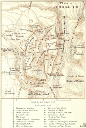
1870s maps of jerusalem
maps from encyclopædia britannica
emery walker
illustrations from five weeks in a balloon by riou and montaut
old maps of africa
maps from the earth and its inhabitants, vol. iii
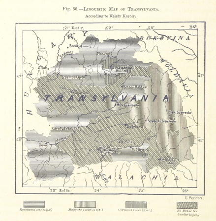
linguistic maps of the balkans
maps from the earth and its inhabitants, vol. vii
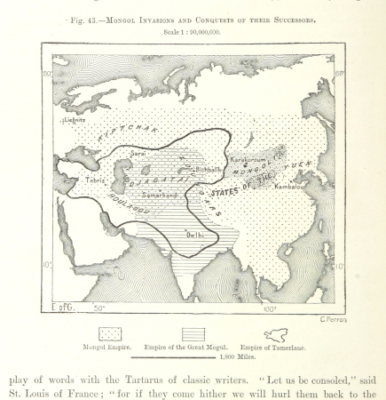
maps of the mongol empire
maps from the earth and its inhabitants, vol. xiii
maps indicating exploration
maps from the earth and its inhabitants, vol. iii
1870s maps of belgium
maps from the earth and its inhabitants, vol. v
1870s maps of norway
maps from the earth and its inhabitants, vol. vii
1878 maps of asia
maps from the earth and its inhabitants, vol. vi
maps of weather and climate of asia
maps from the earth and its inhabitants, vol. xvi
1870s maps of panama
maps from the earth and its inhabitants, vol. vi
maps of the history of russia
maps from the earth and its inhabitants, vol. viii
1870s maps of india
maps from the earth and its inhabitants, vol. xi
1870s maps of tunisia
maps from the earth and its inhabitants, vol. ix
1870s maps of jerusalem
maps from the earth and its inhabitants, vol. v
1870s maps of russia
maps from the earth and its inhabitants, vol. ix
maps indicating exploration
maps from the earth and its inhabitants, vol. viii
1870s maps of india
book covers from the british library mechanical curator collection
adolphe giraldon
corona and coronet (1898)
1898 maps of the world
maps from the earth and its inhabitants, vol. ix
old maps of the holy land
the comprehensive history of england (1876)
english-language maps showing history
anteckning om krigshändelserna i kurland
maps of the great northern war
flandria illustrata
antonius sanderus
old maps of el hierro
history of el hierro
maps by willem and johannes blaeu
title pages of atlases
maps of the spanish-american war
1890s maps of the philippines
john rocque's 1746 map of london
old and new london (book)
maps from the earth and its inhabitants, vol. iv
halifax, yorkshire
maps of the spanish-american war
1890s maps of the philippines
dr. wilh. junker's reisen in afrika 1875-1886
1880s maps of sudan
geological maps of pennsylvania
1885 maps of philadelphia
geological maps of pennsylvania
1885 maps of philadelphia
malebné cesty po praze (1884)
old maps of czechia
old maps of the strait of gibraltar
a school geography (1898) by bird
atlas ou representation du monde universel t. 2 (1633)
old maps of the republic of genoa
atlas ou representation du monde universel t. 2 (1633)
maps by hendrik hondius the younger
maps from the earth and its inhabitants, vol. vi
latin-language maps
thomas robert macquoid
maps of the ardennes
geographia universalis (1545) in the british museum
german renaissance,northern renaissance
civitates orbis terrarum. de praecipuis totius universi urbibus. liber secundus
maps of kleve by braun & hogenberg
civitates orbis terrarum. de praecipuis totius universi urbibus. liber secundus
maps of neuss by braun & hogenberg
civitates orbis terrarum. de praecipuis totius universi urbibus. liber secundus
maps of wissembourg by braun & hogenberg
géographie générale; physique, politique et économique (1876)
1870s maps of germany
maps from the earth and its inhabitants, vol. xvii
anton francesco lucini
nouvelle géographie universelle, vol. xii
old maps of la gomera
géographie générale; physique, politique et économique (1876)
1870s maps of china
19th-century maps of southern africa
1890s maps of africa
geographia universalis (1545) in the british museum
german renaissance,northern renaissance
maps from the earth and its inhabitants, vol. iv
topographic maps of ireland
maps from the earth and its inhabitants, vol. xv
19th-century maps of british columbia
maps of rivers of senegal
bafing river
maps from the earth and its inhabitants, vol. ix
maps of telegraph lines
old maps of south africa
maps of the great trek
maps from the earth and its inhabitants, vol. iv
maps of portland, england
maps from the earth and its inhabitants, vol. xv
maps indicating exploration
maps from the earth and its inhabitants, vol. x
19th-century maps of egypt
maps from the earth and its inhabitants, vol. xv
exploration of the arctic
the dominion of portugal in africa (1889)
maps of cefala by braun & hogenberg
maps from the earth and its inhabitants, vol. iv
topographic maps of the united kingdom
old maps of la gomera
1878 maps of spain
maps from the earth and its inhabitants, vol. xii
19th-century maps of senegal
maps from the earth and its inhabitants, vol. iv
old maps of the lake district
maps from the earth and its inhabitants, vol. xiii
maps of weather and climate of south africa
maps from the earth and its inhabitants, vol. xv
19th-century maps of british columbia
maps from the earth and its inhabitants, vol. xiv
1870s maps of new zealand
maps from the earth and its inhabitants, vol. vii
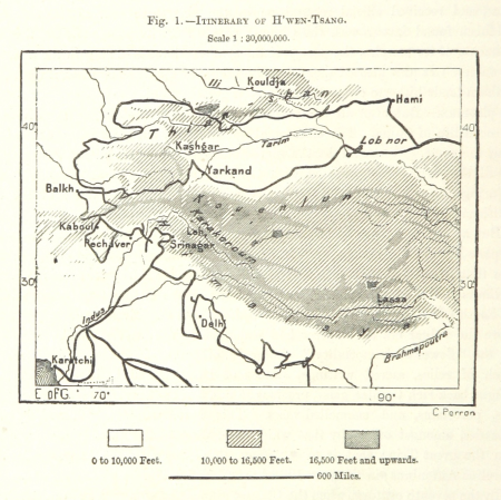
maps of xuanzang's travels
maps from the earth and its inhabitants, vol. iv
maps of loch fyne
301 - 400 of 5,084
Next page
/ 51


![Gerardi Mercatoris and I. Hondii Atlas or Representation of the Universal World, and of the Parts of It, Made in Tables and Very Ample Descriptions. [t. 2].](https://cdn.creazilla.com/illustrations/10000735247/gerardi-mercatoris-and-i-hondii-atlas-or-representation-of-the-universal-world-and-of-the-parts-of-it-made-in-tables-and-very-ample-descriptions-t-2-sm.webp)
![Gerardi Mercatoris and I. Hondii Atlas or Representation of the Universal World, and of the Parts of It, Made in Tables and Very Ample Descriptions. [t. 2].](https://cdn.creazilla.com/illustrations/10001261552/gerardi-mercatoris-and-i-hondii-atlas-or-representation-of-the-universal-world-and-of-the-parts-of-it-made-in-tables-and-very-ample-descriptions-t-2-sm.webp)